


PROFESSIONAL UAV SURVEYS AND TECHNICAL SOLUTIONS

SERVICES

Surveying & Mapping
At Dronetec Consults, we combine traditional land surveying with cutting-edge drone photogrammetry to deliver fast, accurate, and cost-effective mapping solutions.
Using high-resolution drones and GNSS technology, we capture georeferenced imagery to generate orthomosaics, 3D models, digital elevation models (DEM), and contour maps. Whether for land development, engineering design, or property demarcation, our services reduce field time while increasing precision and efficiency.

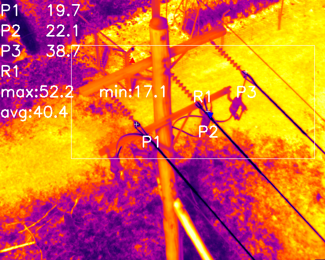
Monitoring & Inspections
Dronetec Consults provides high-resolution drone-based monitoring and inspection services for a wide range of industries including construction, agriculture, utilities, and infrastructure.
Using advanced drones equipped with zoom cameras and thermal sensors, we deliver detailed visual and thermal data to help you track progress, detect faults, and ensure safety—all without risking human lives or disrupting operations.

Drone Lidar Surveys
At Dronetec Consults, we offer advanced LiDAR drone surveys using state of the art equipment for fast, accurate, and high-resolution terrain mapping. Whether you're working on engineering design, land development, forestry, mining, or infrastructure planning, our LiDAR surveys deliver reliable elevation models, point clouds, and contour data with exceptional detail and accuracy.

ABOUT
Dronetec Consults is a Professional Drone/UAV Services, Training & Sales Business in Accra, Ghana within Sub Saharan Africa specializing in autonomous and manual data acquisition, near real-time data feeds, and providing precise Land surveys and photogrammetric mapping information services.
We provide aerial services and solutions to a variety of clients in key sectors such as Mining, Agriculture, Construction, Forestry, Oil and Gas.
Our team is made up of GCAA Certified Drone Pilots, Instructors, GIS Experts and Engineers.
Our goal is to offer clients the most affordable UAV mapping and surveying solutions.
75,000Hrs
10000
3X
2X
Drone Flight
Experience
Surveys Completed By Team
Cost Effective
Accurate
PROJECTS


CLIENTS


CONTACT
Inquiries
For any inquiries, questions or commendations, please call: +233541512712/ +233555281229
Head Office
Contact Us
Employment
To apply for a job with Dronetec Consults Limited, please send a cover letter together with your C.V. to: droneteclimited@gmail.com
Get a quote: 054-151-2712